Black Point to Lake Jasper Track
 This describes how to get from the Bussell Hwy, to Black
Point, then on to Lake Jasper and back to the Vasse highway. This trip takes in the
scenery of the Scott National Park's "4WD country" and includes some gravel
roads, sandy tracks, easy hill climbs, coastal views, then finally, the awesome Lake
Jasper. This trip starts on the Bussell highway, at the Nannup turnoff (Brockman Highway),
which is between Margaret River and Augusta. Although this route is passable with full
tyre pressure, I would suggest letting your tyres down to say 20psi when the track gets
sandy, to avoid cutting the track up.
This describes how to get from the Bussell Hwy, to Black
Point, then on to Lake Jasper and back to the Vasse highway. This trip takes in the
scenery of the Scott National Park's "4WD country" and includes some gravel
roads, sandy tracks, easy hill climbs, coastal views, then finally, the awesome Lake
Jasper. This trip starts on the Bussell highway, at the Nannup turnoff (Brockman Highway),
which is between Margaret River and Augusta. Although this route is passable with full
tyre pressure, I would suggest letting your tyres down to say 20psi when the track gets
sandy, to avoid cutting the track up.
| 0Km | Start at Petrol station at corner of Bussell Hwy and Brockman Hwy, heading East |
| 14.8 | Turn right into Cortny Road, which is Bitumen |
| 19.5 | Turn left into East Augustus Road, gravel |
| 21.6 | Turn right into Scott Road, which is Bitumen |
| 24.6 | Road becomes gravel |
| 26.4 | Pass road on left, continue ahead |
| 30.2 | Turn left into track named Milyianup Road. Do not follow the main road which veers sharp right. Sign says Scott National Park. This is a single lane, sandy track, which has many bends and hills - caution. |
| 40.4 | Y-junction, veer left staying on main track |
| 41.3 | Track becomes good condition gravel. Up to 80Kph. |
| 42.5 | Turn right at T-junction into Woodaburup Road |
| 42.8 | Y-junction, continue ahead on main track. Sign says "Welcome to 4x4 country" |
| 49.6 | Pass sign saying "Gingilup Swamps Nature Reserve". Good condition sandy track. |
| 52.3 | Track deteriorates. Becomes sandy and corrugated |
| 53.2 | Boggy sand patch, and small hill climb |
| 55.4 | Pass cross road, continue ahead. Road then veers to the left and becomes corrugated |
| 56.8 | Enter a thickly vegetated thicket. Several small hills follow. |
| 59.3 | Turn right into track. Do not go ahead into no thru road. Small hill climb follows, which can be rutted at times. |
| 60.8 | Enter D'Entrecasteaux National Park |
| 64.0 | Turn right at intersection towards Black Point. (Note: left at intersection goes through swamp land, and is in-passible in winter. Straight ahead at intersection goes to Lake Jasper, as described later in these notes) |
| 66.2 | Pass several tracks going off to campsites, continue ahead. Several boggy patches, may need 1st gear high is Ok |
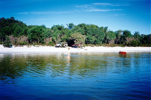
| 66.4 | Arrive at Black Point campsite, overlooking beach. Equipped with BBQs & toilet. Great view, fishing and surfing. After taking in the scenery of Black Point, head back out the same track, back to the intersection of 64k. |
| 68.8 | Turn right at intersection towards Lake Jasper. You are now back on the same track (Wappett Track). Track can be a bit boggy for the next few Ks |
| 75.5 | Nice view of the ocean on the right |
| 76.7 | Turn Right at T-Junction towards Lake Jasper. (Note: turning right at T-Junction takes you to Jasper Beach, but I ran out of time on this trip!) |
| 78.7 | Vegetation becomes very thick and lush, as you go through a swampy area |
| 81.5 | Track goes down a hill. You get your first glimpse of Lake Jasper to the left. |
| 81.7 |  Take side track to get around fallen tree. Sign says "warning vehicle
damage due to branches" so proceed with caution. If your vehicle has a roof rack,
remember to allow for it's height when going under low branches! Take side track to get around fallen tree. Sign says "warning vehicle
damage due to branches" so proceed with caution. If your vehicle has a roof rack,
remember to allow for it's height when going under low branches! |
| 82.5 | Turn Left at the T-Junction |
| 84.3 | Veer left at the slight Y-Junction. Watch out for low overhanging branches. |
| 87.0 | Clearing, possibly a campsite. |
| 87.2 | Turn left at T-Junction towards Lake Jasper. (Note: Right at T-Junction is Scott Road, which is the way out) |
| 89.8 | Sign says "welcome to Lake Jasper". Veer right at Y-Junction |
| 91.8 | Turn Left onto short track to a white sandy beach on the side of the Lake.
This is a top spot for a swim, Kayak, lunch, getting a tan, etc. When you are ready to
leave, follow the same track out, back to the T-Junction. |
| 96.5 | Turn Left at the T-Junction into Scott Road, towards the Vasse Highway |
| 97.4 | Pass track on the left that leads to Lake Wilson |
| 98.0 | Pass track on the left that leads to Lake Smith. Track gets better now, up to 40Kph |
| 100.9 | Pass track on the left called "Pneumonia Road" |
| 103.2 | Pass track on left. This track leads to a monster river crossing of extreme difficulty. Don't attempt unless you are driving a Hummer, with a Unimog recovery vehicle! |
| 103.6 | 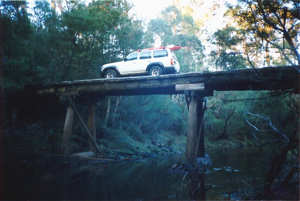 Cross over Donnelly River on an
old log bridge. Note: The load on this bridge is 5 Tonnes, which is about 2 vehicles. I
would suggest 1 vehicle at a time though, as it is getting old. The Load is NOT 5 Toyotas,
as someone has written on the sign!!! This is a great photo spot. Cross over Donnelly River on an
old log bridge. Note: The load on this bridge is 5 Tonnes, which is about 2 vehicles. I
would suggest 1 vehicle at a time though, as it is getting old. The Load is NOT 5 Toyotas,
as someone has written on the sign!!! This is a great photo spot. |
| 103.7 | Exit D'Entrecasteaux National Park |
| 103.8 | Take detour around fallen tree |
| 104.9 | Pass track on right called Klee Road. rack becomes gravel now. |
| 105.5 | Pass road on left, continue ahead |
| 106.2 | Pass tracks on both sides. Continue ahead on main track. |
| 107.7 | End of track. T-Junction at bitumen road, which is the Vasse Highway. Turn Right for Pemberton, Left for Nannup. |


![]()
These pages were last
updated on 8th April 1999.
Hits since 29th October 1998: